

The Channels
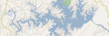
One of the many wonderful features of Smith Mountain Lake is the numbered navigation channel marker system on both the main channels and the tributaries. The Roanoke Channel numbers start at R1 near the dam and extend west, then north/northwest, toward Roanoke, ending with R80 near the Hardy Bridge.
The Blackwater Channel and all other marked channels are numbered starting at the point where they join the main channel and work up from there. C1, for example, would be the first marker where Craddock Creek joins the Roanoke Channel near the chain of three islands northwest of the dam. As boaters proceed up through the C series, they would be progressing north on Craddock Creek to its end at C8 near Mariner’s Landing.
Not only are the channel markers numbered, but they are color-coded and lighted for navigational ease. Red and green lights guide a boater through the center of the channel at night, and the numbers make it easy to stay on course by day. With a map in hand, this system makes Smith Mountain Lake a prime place to fish by day or night year-round.
I have taken many clients and friends out to dinner by boat and returned home with relative ease late at night. My wife and I enjoyed the full moon rising over Smith Mountain by boat before midnight on her birthday last August 3rd. It would have been challenging to make this beautiful memory without the wonderful navigational marker system. A handheld or boat-mounted GPS also works great here, showing the details of channels, coves, and inlets across our vast mountain lake.
The Shoreline
Though Smith Mountain Lake has only about 40 miles of main river channels, it boasts an impressive 500+ miles of total shoreline. This figure is staggering as one considers that this is the approximate highway distance from here to New York City! This shoreline figure is a testimony to the many large tributaries that flow into the lake as well as the lovely, rolling nature of the Blue Ridge Mountain terrain that makes up Smith Mountain Lake’s borders. This terrain gives Smith Mountain Lake many hundreds of coves, inlets, twists, and turns that make for breathtaking views, marvelous home sites, and practically unlimited spots to anchor a boat for a picnic lunch, swim, watch a romantic sunset, or catch a double-digit weight striped bass.
The Islands
In addition to its many coves and inlets, the rolling Blue Ridge Mountain terrain has provided Smith Mountain Lake with many lovely islands. These islands are formed from old mountaintops or ridge lines. A few of these islands are privately owned but most are available for the public’s enjoyment. Boaters regularly anchor their crafts offshore, providing a place for kids to wade in the sand and swim. Some stop for a picnic lunch or explore the trails. Many people have found great fishing holes off island shores.


Comments 2
Hello Paul,
I will be moving to the Roanoke area in the next few years. My question is: On Goggle Earth, I see a marina…..on the south side of the Hardy Bridge……is this a marina, public or private, or a boat dealership? Thanks, Mark
I’m a Realtor that works with Paul Moore. He is actually out of the country right now…so I’m replying to answer your question.
I believe the property you are referring to is a public marina called Bay Roc Marina…which is a full service marina and the sell new/used boats as well. Just about 300 yards from that marina…there is a also a popular public boat launch ramp as well. This marina and boat launch are the most convenient ones for most folks in Roanoke to use.